
Page 69 - Electronic Navigation Cyber Book
P. 69
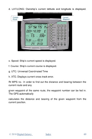
d.  LAT/LONG:  Ownship’s  current  latitude  and  longitude  is  displayed.


          e. Speed: Ship’s current speed is displayed.


          f. Course: Ship’s current course is displayed.

          g. UTC: Universal Coordinated Time

          h. XTE: Displays current cross track error.

          Rt WPS no.: In order to find out the distance and bearing between the
          current route and any

          given waypoint of the same route, the waypoint number can be fed in.
          The GPS automatically


          calculates  the  distance  and  bearing  of  the  given  waypoint  from  the
          current position.


           © 2018 Digital Galaxy               Index                                69